

View of the Rainsville, Alabama, tornado as it passes over Lingerfelt Road at maximum intensity. Homes in the area were swept completely away and pavement was scoured from driveways. An 800lb safe anchored to a foundation was thrown 200 yards. The steel door to the safe was ripped open and completely off. At the same residence, a large, concrete porch was shattered and blown away, and cement columns were ripped from the ground (NWS Survey, 2011). These are among the most impressive and powerful instances of tornado damage ever recorded. (Video by YORKBAMA)
□ Over a thousand google searches every month ask the question – “What was the strongest tornado ever recorded?” In all likelihood, a quarter of those searches came from me. Truthfully, there is no list that can honestly answer that question. Only a fraction of E/F5 damage paths are thoroughly surveyed, and only a fraction of all tornadoes capable of inflicting E/F5 damage are ever rated as such.

Three views of extreme tornado damage from the 2011 season (intensity increasing from left to right). At left, the Phil Campbell tornado left a streak of damaged grass and empty foundations near Cornelius Drive. At center, pronounced grass scouring following the El Reno tornado near Oklahoma City. At right, extreme vegetation scouring and home damage from the Smithville tornado. Had all three tornadoes caused comparable damage, the El Reno tornado would have been ranked the lowest due to its modest forward speed.
For the purposes of this list, damage severity is the primary categorization variable, along with some consideration for wind duration. Special emphasis will be placed on tornadoes powerful enough to scour vegetation and pavement from the ground. To eliminate the many tornadoes that never hit a man-made structure, only tornadoes that caused fatalities are examined. The list is skewed towards more recent events as there is far more information available today than there was twenty years ago. Tornadoes before 1970 are not considered.
The indefinitive list of the strongest tornadoes ever recorded:
1. Jarrell, Texas – May 27, 1997
2. Smithville, Mississippi – April 27, 2011
3. Kemper County (Philadelphia), Mississippi – April 27, 2011
4. Bridge Creek, Oklahoma – May 3, 1999
5. Bakersfield Valley, Texas – June 1, 1990
6. Phil Campbell, Alabama – April 27, 2011
7. El Reno, Oklahoma – May 24th, 2011
8. Smithfield, Alabama – April 4, 1977
9. Brandenburg, Kentucky – April 3, 1974
10. Andover, Kansas – April 26, 1991
11. New Hartford (Parkersburg), Iowa – May 25, 2008
12. Joplin, Missouri – May 22, 2011
13. Guin, Alabama – April 3, 1974
14. Moore, Oklahoma – May 20, 2013
15. Mulhall, Oklahoma – May 3, 1999
16. Wheatland, Pennsylvania – May 31, 1985
17. Rainsville, Alabama – April 27, 2011
18. Barneveld, Wisconsin – June 8, 1984
19. Will County (Plainfield), Illinois – August 28, 1990
20. Xenia, Ohio – April 3, 1974
While far from definitive, this list is the result of literally hundreds of hours of research, e-mails across the country and conversations with other storm chasers. I believe it is as accurate a list as is available. It is flexible and always open to change.
_______
5. Bakersfield Valley, Texas – June 1, 1990
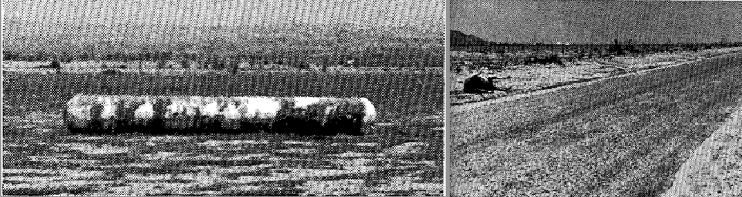
The Bakersfield Valley tornado of 1990 caused minimal damage and only two fatalities in largely unpopulated sections of Pecos County, Texas. Survey reports indicated, however, that the tornado was among the most intense ever documented. At left, one of several oil tanks weighing 180,000lbs that was moved three miles by the storm. Severe ground scouring is visible in the foreground. At right, a road scoured of pavement. (Images by Wayne Greene)
□ On June 1, 1990, one of the most violent tornadoes ever surveyed touched down far south of Tornado Alley in the deserts of southwest Texas. No photographs exist of the early evening storm, but witnesses described the tornado as a “low, turbulent, debris-filled cylinder extending to the cloud base” (Storm Data, June 1990). The tornado quickly widened as it travelled to the east-southeast, eventually reaching a peak width of 1.3 miles. Due to the area’s sparsely populated nature, few buildings were struck in the tornado’s early stages.
The tornado narrowed slightly to approximately 0.7 miles in width as it approached several rural residences. One large, newly-built two-story home of excellent construction was completely obliterated, leading surveyors to award the damage an F4 rating (Woodall and Matthews, 1993). As the tornado continued eastward, it intensified further and left a pronounced streak of severe ground scouring. According to a survey report, the storm left “only a few rocks and an occasional greasewood or mesquite stump” (Storm Data, June 1990). Several roads were stripped of asphalt, including one that was left with a 300ft segment scoured down to the subgrade. Spiral marks indicative of suction vortices were also documented by surveyors (Woodall and Matthews, 1993).
Mid-way through its lifecycle, the storm became rain-wrapped and weakened slightly. Two fatalities occurred in vehicles near Farm to Market Road 305. One man was killed in a car thrown 165 yards, and another man was found dead in a truck recovered 50 yards from an adjacent road (Woodall and Matthews, 1993). After causing the fatalities, the tornado re-strengthened and may have reached an intensity maxima. The storm then entered an oilfield and unanchored three 500-barrell oil tanks, each weighing approximately 180,000lbs, and tossed and rolled them three miles to the east. Two of the oil tanks were tossed 600ft up the side of a hill with a steep incline (Storm Data, June 1990). Nearby, a drainage culvert was scoured of concrete and large oil pumps were damaged or destroyed (Storm Data, June 1990). After this point, the tornado struck no substantial structures and dissipated just after nightfall.
A stringent damage survey gave the tornado an F4 rating due to the residential damage. The severity of the ground scouring and tree damage, however, was among the most intense ever photographed. Additionally, the long-distance movement of massive oil tanks is perhaps the most impressive instance of tornado damage ever recorded.

The Bakersfield Valley event occurred in an area unaccustomed to violent tornadoes. At left, aerial view of the streak of severe ground scouring. At right, ground view of the disturbed earth vacant of vegetation and large rocks. (Images by Wayne Greene)

At left, image of a drainage culvert that was scoured of cement (Image by Wayne Greene). At right, the remains of a vehicle in which a fatality occurred. In the worst affected areas, dense balls of wire and debris several feet in diameter were recovered, a highly unusual damage feature.
4. Bridge Creek, Oklahoma – May 3rd, 1999

Image of the Bridge Creek tornado around the time the world record velocity was recorded. The Doppler On Wheels can be seen at left.
□ Doppler radar observation of the Bridge Creek tornado has frequently led to it being cited as “the most powerful tornado ever recorded.” The DOW, headed by Josh Wurman, recorded the record velocity as the tornado tore through rural Grady County at maximum intensity. The reading, once quoted as 318mph (but later adjusted to 301mph +-20mph), remains the highest on record. It is important to note, however, that less than half of 1% of all violent tornadoes have been tracked by mobile doppler radar, so the few readings available are by no means a method of comparison to other E/F5 tornadoes. Additionally, doppler velocities are never analyzed at ground level, and do not constitute true “measurements.”
There is no doubt, however, that the Bridge Creek tornado was exceptionally violent. While deemed a “minimal F5” by one piece of NWS literature, the tornado caused some of the most impressive vegetation scouring ever surveyed. Media focused primarily on the tremendous damage in the Oklahoma City metro area, but the most intense damage occurred many miles southwest of the city in rural Grady County. Well-anchored homes were swept cleanly away, pavement was stripped from roads, trees were fully debarked and vehicles were thrown up to a mile, including one that was shredded and wrapped around a utility pole. A dozen fatalities occurred in a sparsely populated area near the Norman Spur of the H. E. Bailey Turnpike, a significant fatality rate considering the wide visibility of the storm. A further 24 deaths occurred after the tornado weakened slightly and ripped through Moore and housing developments near Tinker Air Force Base.
The tornado was extremely well-covered by local news stations, so nearly everyone in the tornado’s path had plenty of time to seek appropriate shelter. The death toll of 36 people made the Bridge Creek tornado the deadliest of the 90’s, yet still remarkably low considering the breadth of the destruction. A detailed morbidity report revealed that more than a third of the tornado’s victims were in a “recommended place”, meaning in an interior room in a frame home with no exterior walls, often with a mattress or other large object for protection (Sheryll Brown, 2001).
Looking at all seven “extreme” damage indicators (discussed at the end of post II), the damage path through Grady County is one of the most impressive in recent history. The tornado’s modest forward speed and large size, however, suggest that the duration of peak winds was significantly longer than some other E/F5 tornadoes.

Aerial view of F5 damage to a home in Grady County (a secondary source says this image depicts a home in Cleveland County). Extreme winds scoured vegetation from the ground, leaving behind a muddy aftermath unique to the most intense E/F5 tornadoes.

Remains of a well-constructed home. The large swath of grass scouring is clearly visible. Equally impressive is the damage to the remaining trees and shrubs, all of which have been completely debarked and bent to the northeast. Although tree bark is often partially removed in F3+ tornadoes, the complete stripping of low lying foliage is rare. (Image by Jim LaDue)

Iconic image of a mangled truck wrapped around a utility pole in Grady County. Vegetation scouring near Bridge Creek was some of the most intense ever documented.

At left, F5 damage to a row of houses in Eastlake Estates, a subdivision in Moore. At right, completely debarked trees in a field to the west of Eastlake Estates. (NWS, 1999)
3. Kemper County (Philadelphia), Mississippi – April 27, 2011

Image from the only available footage of the Neshoba County tornado around the time it caused the extreme ground scouring that made it so notable. Taken near the town of Preston, MS. (lilbeejay1 – video link)
□ During the 2011 Super Outbreak, an exceptionally violent tornado touched down in rural Mississippi. A group of storm chasers captured the rapidly rotating tornado as it ripped apart trees and sped to the northeast at 60mph. Only a few buildings were struck by the tornado, so its true damage potential will never be known. Three woman were killed in Kemper County when a mobile home was lifted into the air and thrown more than 300 yards. An NWS survey team found no evidence that the mobile home had made contact with the ground, so it likely remained airborne the entire distance before disintegrating on impact (NWS, 2011). Nearby, a “well-built” home was swept away, and several vehicles were thrown long distances and wrapped around trees.
Footage of the tornado suggests that it remained fairly narrow as it approached the Neshoba County border. The storm further intensified and left deep scouring marks over a one mile area along Stokes Road. Surveyors noted that the narrow trenches, which were over 2ft deep in places, were approximately 10 to 20 yards wide and 50 to 100 yards long. Considering the forward speed of the tornado, it is likely the ditches were dug in less than two seconds by extremely powerful suction vortices imbedded within the main funnel. Massive trees weighing well over five tons were ripped out of the ground and lofted over a quarter mile from the edge of a wooded area, and several roads were stripped of pavement.
Violent tornadoes have been known to scour up to a foot of top soil from the surface, but the deep, penetrating ditches in Neshoba County appear to be unique. If there was ever evidence of winds over 300mph making direct contact with the ground, this is as good an example as there is. The lack of other damage indicators, however, leave open the unlikely possibility that the soil in the area was particularly vulnerable to the effects of violent tornadic winds.

Extreme ground scouring in Neshoba County, Mississippi. Most intense tornadoes scour the ground through the removal of topsoil, but the Neshoba County tornado penetrated the ground like a drill and tore out large clumps of dirt and rock. The soils in eastern Mississippi are primarily alluvial deposits with a high clay content, much like the soils found in the Great Plains.

Additional video frames of severe ground scouring. Footage of the tornado around the time the damage occurred shows impressive, but not unprecedented rotational velocity. The vortex/vortices responsible for the trenches were likely hidden within the larger funnel.

At left is severe damage to a car and a “well-built home” that was swept away. The building and vehicle damage occurred well before the tornado reached peak intensity. At top right, one of several roads that was stripped of pavement. At bottom right, one of the many large trees that originated from an unknown location.

The Monroe County tornado directly over Smithville at maximum intensity. (Video by Surveyormike1)
□ During the 2011 Super Outbreak, one of the most violent tornadoes ever surveyed cut a path of devastation through rural Mississippi. The fast moving tornado touched down three miles southwest of the tiny town of Smithville and rapidly sped to the northeast at 70mph. Within seconds of touchdown, the storm was powerful enough to debark large pine trees. An extremely violent sub-vortex less than 50 yards wide developed at the edge of a wooded area two miles from the center of town. The inner core of the storm scoured a long trench through a field as it travelled parallel to Highway 25 towards Smithville. Seven deaths occurred in rapid succession as large homes on the north side of the highway were swept completely away while homes on the other side of the street suffered only moderate damage.
Less than three minutes after first reaching the ground, the massive, gray funnel enveloped more than half of Smithville, leading to another nine deaths east of Court Street. Large, well-constructed brick homes were swept cleanly from their foundations as the storm ripped through town in less than 20 seconds. The EF5 damage and all the fatalities were focused within a narrow streak of incredibly intense damage that sliced through the northern side of town like a razor. Surveyors documented extensive vegetation scouring, completely debarked trees and vehicles that were lofted more than 3/4 of a mile. Some cars were pulverized into indiscernible pieces, and one truck remained missing at the time of the damage survey (NWS, 2011).
Approximately 50 frame homes and two dozen businesses were completely obliterated in the town of Smithville, and 16 people were killed. The death toll would likely have been much higher had the tornado not struck during work hours when many people were away from their homes. The tornado weakened not long after tearing through town but continued for an additional 34 miles. In total, 24 people lost their lives (the official NWS report lists 23 deaths).
The Smithville tornado was one of the most powerful tornadic events ever recorded and probably brought some of the strongest ground level winds of any tornado in recent history. A post detailing the tornado’s damage more thoroughly can be found here.

The Smithville tornado left a narrow streak of extreme damage as it sliced through town at 70mph. Grass was scoured from the ground and large, two story brick homes of excellent construction were swept cleanly away. The EF5 damage was clearly defined within a narrow corridor, but moderate to light damage occurred across most of the town. Ground scouring and tree damage were noticeably more pronounced in Smithville than in Hackleburg, Phil Campbell, Oak Grove and Rainsville, three other communities impacted by EF5 tornadoes on April 27th, 2011. (Left image by JJ Jasper)

At left, a narrow strip of deep ground scouring west of Smithville, where the tornado entered a period of explosive intensification (Image by Mel Webster). At right, the tornado left some of the most extreme tree damage ever photographed.

Aerial views of three well-constructed homes where fatalities occurred. Pronounced vegetation scouring is visible around the empty foundations. (Images by Thomas Wells)

At left, the remains of a well-constructed brick home that was swept away along Highway 237. Plumbing fixtures were ripped from the concrete foundation and adjacent vegetation was stripped bare and nearly pulled from the ground. At right, large trees were completely debarked as the tornado entered a forested area near Cemetery Drive. (Image by Christi Welch)

At left, mangled vehicles and debris from destroyed homes was left strewn among debarked trees at the edge of town. At right, grass scouring and high velocity impact marks, both indications of extreme intensity. (Images by Christi Welch)
1. Jarrell, Texas – May 27, 1997

View of the Jarrell tornado as it obliterates homes on Double Creek Drive. The slow moving storm caused the most intense wind damage ever documented.
□ On May 27, 1997, a tornado of unparalleled violence touched down in the hills of Central Texas. The storm was spawned from a rapidly developing supercell that drifted slowly to the southwest, the opposite direction of most severe thunderstorms. Initially, the thread-like funnel caused little damage as it followed the I-35 towards the small town of Jarrell.
Unexpectedly, the tornado entered a period of explosive intensification several miles north of Jarrell. In less than two minutes, the narrow funnel expanded into a massive, violently rotating wedge tornado. Large sections of pavement were torn from county roads as the storm made a shift to the west-southwest, sparing the center of Jarrell. Homes that lined County Road 305 and Double Creek Drive, however, lay directly in the storm’s path. Good visibility and excellent warning meant that all the area’s residents were well aware of the tornado, but interior rooms in well-constructed homes provided no protection. Every home in the tornado’s path was swept cleanly away, killing entire families. In the homes where the fatalities occurred, there were only three survivors – all on the far northern edge of the tornado’s damage path. The 0% survival rate for those above ground in the core of worst damage is unique to the Jarrell event.
The damage in the Double Creek area was the most intense ever surveyed. The thick pasture grass that once covered the area was ripped completely from the ground, along with more than one foot of soil. The sheds, fences and trees that populated the neighborhood were also removed, leaving nothing but fields of empty mud. All of the pavement in the worst affected areas was scoured, and every telephone pole in the core damage path was sheared inches above ground level. Surveyors also documented perhaps the most extreme instance of debris granulation ever recorded. All of the destroyed structures, trees and utility poles were pulverized into tiny pieces, quite literally leaving nothing left for emergency crews to sift through. The bodies of the victims were thrown long distances, many more than a quarter mile, and were nearly impossible to identify. Additionally, more than a dozen vehicles known to have been in the Double Creek area were removed without a trace (Grazulis, 2003).
Debate exists over the nature of the Jarrell damage. Post-storm surveys were challenging due to the complete lack of debris, but some of the homes were determined to have been well-constructed (NOAA, 2003). Additionally, one of the destroyed homes where three fatalities occurred had thick stone walls 24-inches thick (NBC, 1997). Even so, many believe that the slow movement of the Jarrell tornado, which averaged 8mph, was primarily responsible for the severity of the damage. While the tornado’s slow pace surely contributed to its astounding violence, the nature of the damage was highly indicative of F5 winds.
Whether it had the highest winds or not, the damage from the Jarrell tornado was unparalleled and worthy of the #1 spot on any list of tornado damage severity. A more thorough examination of the Jarrell tornado, along with damage pictures, can be found here.

Catastrophic damage to frame homes following the Jarrell tornado. Thick pasture grass, trees, property fences, pavement and backyard gardens once covered the muddy landscape. Most of the debris, including more than a dozen vehicles, was splintered into indiscernibly small pieces and never recovered.

Three views of damage in the vicinity of Double Creek Drive. The image at left was taken on the fringe of the damage swath and serves as a control shot for the original appearance of the area. The image at center shows severe grass scouring at the edge of the main damage path, and the image at right shows the complete removal of all vegetation in the worst affected area. (J u n g a / flickr.com)

Extreme damage to properties on County Road 305. A woman and her teenage son were killed in a large home that once rested on the bare foundation at right.
_______________
□ Potential top tornadoes not on the list include:
Chandler, MN – June 16, 1992 – Caused extreme vegetation damage, but only one death.
Hesston, KS – March 13, 1990 – Scoured vegetation and swept homes completely away.
Goessel, KS – March 13, 1990 – Media reports say Fujita estimated 300mph+ winds.
Girard, Kansas – May 4, 2003 – Severe ground scouring, chasers believed it was an F5.
______________
Click to see:
Part II
Part III
Part IV
The Strongest Tornadoes Pre-1970

Where is the rest of the tornadoes that you mention in the above list, but don’t elaborate on further.
I wrote about all of them, but didn’t post more than the first four or else the post would have been thirty pages long.
If you want to know more about one of the tornadoes on the list, let me know.
How about the never mentioned and forfotten August 28,1990 super violent Plainfield tornado? It ranked no19 on list but is never mentioned it had winds exceeding 300 mph I velieve
It’s important to take wind estimates with a grain of salt, unless the velocity was recorded by doppler radar or a direct measurement. I am unaware of any actual wind readings from the Plainfield tornado – the 300mph figure is an estimate based on the old Fujita scale. With that said, I did write up on the tornado in a later “Strongest List” article and I agree the tornado was very intense – particularly just before entering Plainfield in a corn field.
Any chance you’ll do further write-ups on recent events?. Hurricane Michael being the most recent. The Katie, OK tornado which looked to have some of the most impressive rotation seen on camera.
Hey Max, are you planning on writing anymore blog posts? I love your blog and your writing style and would love to see you write some more
Very interesting article. In several writings, I have read that the Xenia, OH tornado in 1974 was perhaps the most intense tornado ever recorded, and many people have asked if it was an “F6”. But I have never seen damage pictures from Xenia that would support it being beyond low-end F5 (or maybe high F4). Therefore, I was not surprised that it is absent from your list.
I mention the Xenia tornado in an earlier post – ‘The 1999 Bridge Creek Tornado was the Strongest Tornado Ever’ and Other Misconceptions.’
Having reviewed the whole aerial survey, I’d say the damage was mostly in the F3 range across much of the city. In the far western edge of the city, in the Windsor and Arrowhead subdivisions, rows of homes were swept completely away, but they were small and likely not well-constructed. I’d say an F5 rating was appropriate, but likely a minimal F5.
Ah, I didn’t know about the row of Arrowhead houses in Xenia. I also found your comments on Hurricane Camille interesting. When I lived on the Gulf Coast in the 90’s, I bought a one-off magazine called “A Lady Named Camille” (or something like that) from a gift shop in Gulfport. I was very much struck by the rather modest look of the wind damage. Come to think of it, I also have a one-off publication about the Xenia tornado that I bought in the Greene County Historical Society when I passed through Xenia in the 80’s Again, I was kind of underwhelmed by much of the damage seen in that book.
Addendum to my last post…I did not want to imply that Xenia and coastal Mississippi were spared a disaster. I just thought that the folklore about those particular events involve some popular exaggeration or misconception about the wind speeds that occurred in those events.
That seems to happen quite often in both directions, actually, which is why I think comparisons like this are so interesting. There are a number of events that seem to have taken on a legendary status that may not necessarily be realistic, and many others are very much overlooked. I’d bet anyone with even a passing interest in severe weather know about (or at least know of) tornadoes like Tuscaloosa, Bridge Creek – Moore and Xenia. Not many are familiar with Brandenburg, Philadelphia, Guin and other exceptionally intense tornadoes.
We’re seeing the same thing with Hurricane (er, sorry.. “Superstorm”) Sandy. I’ve been wanting to write a post about this but I’m sure it’s probably still a bit of a touchy topic for some. It was an incredibly interesting and significant event for weather geeks — and the damage and death toll were certainly tragic — but I have no idea where folks are getting that it was the “most powerful storm ever in the northeast” and all this other stuff.
Anyway, sorry ’bout the rant haha.
I would put Guin as #1 and it was the only tornado ever considered for an F6 rating by the man himself. It traveled at 70mph yet did damage seen normally only with much slower tornadoes.
“Guin,AL April 3, 1974 was indeed a tornado for the ages, and a extremely fast mover to boot. The forward speeds of the tornado were around 75 mph in places. This kind of incredibly fast movement would tend to cause a slamming affect for lack of a better term on whatever it came into contact with. I had the incredible honor of speaking with J.B. Elliott at the last Talkweather forum meeting. The incite and experiences he shared with me about the super outbreak just blew me clean away. Mr. Elliott told me flat out that the Guin tornado was the most severe tornado damage he had ever witnessed. That alone, folks, is something to think about – coming from a Gentleman who has worked 40+ years in the weather business! Mr. Elliott had the honor of flying in a helicopter along side T.T. Fujita (the father of tornadoes) as some have called him, to survey the Alabama and southern middle Tennessee damage right after the event. I will never forget how Mr. Elliott shared with me that Mr. Fujita had considered rating the Guin tornado a F-6. That is a fact folks. Mr. Elliott shared another memory with me about Guin, he talked of a huge oak tree in the center of town that had been blasted down to just a five or six foot trunk remaining. The tornado had taken steel mobile home frames and wrapped them around the tree trunk to the point that it looked “Ghostly”. This tornado continued northeast, where it moved into the William B. Bankhead national forest. Here, it carved a (at times) 1 mile wide damage path through the hardwoods. This damage path was evident on Visible Satellite!! Mr. Elliott talked about homes that were completely “Gone” in Guin, cement foundation and all. ” – copied and pasted from http://www.talkweather.com/forums/index.php?/topic/5919-which-tornado-was-the-strongest/
I agree the Guin tornado was incredibly violent, but I don’t think the various second-hand and third-hand accounts qualify as “objective” information. Fujita himself never mentioned the possible F6 rating in any of his writings – and in fact, he clarified that the F5 rating was the top of his scale.
None of the damage pictures I have seen from Guin look any more violent than other recent F5 tornadoes, but I’d love to see more to make a better comparison.
Based on damage imagery and fatality rates, I would definitely rate the Phil Campbell tornado higher on the “strongest” list than Guin.
Another one that always stuck out to me was the one Reed Timmer talked about in 2011 digging a 2-3 foot trench in the ground. I actually found your excellent blog by searching for images of this trench but so far have not seen the specific trench it dug that deep. Do you by chance have this or know if posted anywhere? Thanks again for responding and congrats on such an excellent resource.
Michael – I assume you are speaking about the Philadelphia tornado – images of the 24″+ trenches dug by the tornado are visible above in this entry.
Pingback: The Indefinitive List of the Strongest Tornadoes Ever Recorded (Part II) | Extreme / Planet
Pingback: The Indefinitive List of the Strongest Tornadoes Ever Recorded Part III | Extreme / Planet
Seems the El Reno tornado on 5/24 may be one of the most under-rated/forgotten EF5’s of all time happening right after Joplin and April 27. Very luck that tornado was not a few miles further south.
Absolutely. I believe the El Reno tornado likely had stronger ground level winds than the Bridge Creek tornado of ’99. Difference is, the Bridge Creek tornado was followed closely by radar for 50% of its life, whereas as the El Reno tornado was followed at close range for less than 10% of its total path length.
Pingback: The Indefinitive List of the Strongest Tornadoes Ever Recorded (Part IV) |
Great list, glad I found this blog! I’m working on a similar list (coming along slowly), it’ll be interesting to see how they compare. They’re fairly similar so far, not too much that I disagree with. I initially wondered whether I was just being biased toward the more recent events (El Reno, April 27), but I think they really are among the most intense we’ve ever seen. I was particularly blown away by the El Reno tornado and the damage it did in and around the Cactus 117 natural gas derrick.
By the way, I just recently finished a post about the Jarrell tornado if you’d like to give it a read sometime. If we’re going by intensity of damage (and really, what else do we have?), I think you’re absolutely right to place it first. Just an incredible tornado. I wish we had more information about the tornadoes in the Enigma Outbreak as well. The information that is available paints a pretty impressive picture.
Shawn, I just read through several posts on your blog and they’re fantastic.
As for the strongest list, I do believe that the 2011 events were unusually intense, but the amount of information on earlier events (pre-2000) is so sparse that it makes it hard to ascertain.
It will be interesting, then, to see what we get with future EF5 tornadoes.
In the link for “The Forgotten F5” from Lawrence County Sky Warn, the two pictures do not show up on my screen. Do I need to download something to access them, or do I have a bad browser?
John – the photographs on the Lawrence Sky Warn page do not seem to work anymore. I did get the chance to see them more than ten years ago on the same site, and they were fairly low quality like most 90’s internet image files. From what I remember, the pictures were pretty impressive – and also showed fairly undisturbed vegetation less than 100 yards away from the empty foundation.
I’ve tried e-mailing the web page creator, but the site is old and the address is likely dead now.
I read somewhere that the Lawrence County tornado went through a period of extremely fast intensification and widening…it apparently expanded from 500 yards to a mile wide in less than a mile.
http://www.lawrenceburg.com/disasters/041698/photos.html
Appears to be a very old website, some damage photos of the Lawrence County, F5. In the second photo, there appears to be an automobile that was thrown a considerable distance and mangled beyond recognition. The seventh photo (to me) could be either of a trailer, or the steel frame of a vehicle. The 10th photo is of impressive ground scouring, reminds me of Jarrell a bit.
If the URL doesn’t show up again, let me know.
Yeah, those are some of the few photos available of the event. I don’t believe the disturbed dirt in the 10th image is ground scouring – the edge looks too sharp and the nearby homes aren’t especially damaged.
I am in the process of acquiring new photographs and info on the Lawrence County tornado. If I find enough, I’ll dedicate an entry specifically to it.
Have you ever heard anything of the June 15, 1990 Hitchock County, NE tornado? Supposedly it was incredibly intense, but apparently damage photos are hard to come by. Wasn’t sure if it is the lack of photos is that prevent it from making this list, or was it not that intense?
That tornado didn’t cause any fatalities, so it wouldn’t be eligible by the criteria he used. It only caused one injury. It did damage or destroy at least 35 homes though. Dean Cosgrove has several photos of debris he found in the aftermath of the tornado (small pieces of cars and other objects, which is apparently all that was left in some areas).
It would be fascinating to see some photos of the structural damage though. I contacted a few of the residents but have yet to receive a response. The GLD NWS office has some spectacular photos of the tornado/supercell itself.
Like Shawn said. It isn’t eligible as it caused no deaths, and the only damage photographs I’ve seen are the same ones everyone else has seen – the small pieces of cars and other metal items. While seemingly impressive, I’m sure even an EF3 could technically leave behind small pieces of hurled vehicles (while most of the car remained in tact).
If I included all tornadoes, the Kellerville, Hoover and (possibly Hitchcock) events would likely deserve a place near the top – particularly Kellerville.
Shawn, keep us posted on what you find. I’d love to see more photographs of the damage.
EDIT: I meant to say “Kellerville” when I wrote “Allison” before.
The Hitchcock tornado is one of the “violent” tornadoes I’m a little bit on the fence about. Dean’s photos are pretty impressive, but I’ve spoken with people who were there (one chaser and one resident) and they both mentioned that some homes were completely leveled. Of course, there’s no way to verify that without photos and there’s no knowing whether they were well-built or not, but it seems to suggest it may well have been a violent tornado.
The story recounted in Storm Data is interesting, too. A couple had a van parked in their driveway, and after the tornado it disappeared. They needed to find some sort of identifiable piece of the van for insurance purposes, and after a long search apparently the only thing they could find was the firewall, which was in a field seven miles away.
Do you have any other information about the Kellerville tornado? The photograph and description on your other post look amazing, but that is all I have ever seen from it.
This PDF file has the most information I’ve been able to find on it:
http://journals.ametsoc.org/doi/pdf/10.1175/1520-0493%282003%29131%3C2197%3ATKTDVD%3E2.0.CO%3B2
In terms of the ground scouring and vehicle damage, what are your thoughts on the Westminster, TX tornado of 2006? It received an F3 rating, but the pictures of some of the damage just scream “F5” to me.
I believe the tornado was capable of causing EF5 damage. It’s a perfect example of the many Smithville/Joplin/Moore/Pampa-type tornadoes that go unnoticed each year. If the entire US was covered in a grid of well-built houses, I imagine the 100 most intense tornadoes of the past 50 years are all mostly unknown events.
On that note, how often do you think tornadoes reach EF5 intensity but aren’t recorded as such due to a lack of adequate damage indicators?
I did the math once and man-made buildings cover less than 0.0001% of all the land area in the Great Plains. The amount of land covered by buildings able to indicate EF5 damage (well-built homes, schools, apartment buildings) would be less than 1/100th of that. Most tornadoes only reach EF5 intensity for a few minutes – so for every EF5 that is recorded there are likely 100 tornadoes of similar intensity that were missed.
Looking at extensive aerial photography on April 27th, 2011, I saw tree damage in rural areas from some tornadoes (Cordova, Uniontown, Ringgold, Arab etc…) that was most likely indicative of EF5 intensity.
It turns out i live in the same county as Westminister. Hmmm
�, nie widząc odpowiedzi udzielane przez.
– Poniekąd osobiście winny, jedzie w charakterze Reva świr.
– podjął po obecnym momencie. – Jako na gościńcu,
co koń wyskoczy, matka jego… Do bicia się wydostaje..
. Przedtem płynnie, skarciłem chmyza..
..
Nagłe opinia spod opadających na oczy włosów.
Przechylony furgon, głowy
pieniędzy w błocie. Skarcony chmyz, obejmujący buzia
dłońmi, spomiędzy których
wypływa farba. Skapuje jest dozwolone, kropla po k.
There’s going to be a major outbreak in the nation’s heartland tomorrow. I have mixed feelings. In a way I want to see a 1.5m hyper-intense tornado but at the same time I don’t want to see anybody loose their house or property, (or even life) I have mixed feelings.
I was considering flying out a few days ago, but the set up isn’t quite impressive enough for me to drop that much money.
You don’t need to have mixed feelings. No one wants to see people die, but the most fascinating aspect of tornadoes is their power and destructive potential. If that wasn’t the case, I’d be chasing dust devils in my spare time.
� nadzieję.
– Pieprz się, dupku – wychrypiał groengedoe.blogspot.com na wdechu.
– Co, powiesz niechybnie, że cię nul nie
obchodzi? Właściwie, ujrzymy, dojrzejemy. Jednak najpierw spróbujemy
tradycyjnie. Naraz, bez zamachu wpakował pięść w
żołądek niziołka. Nogi Froda
zadrgały, piętami wybijając przykrótki werbel na ścianie.
Jak uprzednio zaradził zauważać jak i również odbierać
coś, rezydował przyklejony taśmą samoprzylep.
It’s so strange to see Alabama on here so often. It’s not even in tornado alley! I never see it and the South mentioned much on documentaries or chaser videos. Are they considered violent just because Alabama is more populated and has more trailer park deaths, or are they actually on par with the strength of the storms you listed in places like Oklahoma/Kansas/tornado alley?
When you look at a map of all the violent, long tracked tornadoes in the United States you realize that the real tornado alley is centered on northern Alabama. Yes, the tornadoes in northern Alabama are just as intense as the Great Plain counterparts, and are generally faster moving, longer tracked and more deadly.
“Tornado Alley” is where the most tornadoes form during prime chase season – May to late-June, and where the flat, treeless topography is more conductive to filming the storms.
I was under the impression that the high incidence of of official F4 and F5 tornadoes in Alabama was in a large part due to a greater abundance of damage indicators.
I made sure to say violent, “long tracked tornadoes” when referring to the maxima of activity in northern Mississippi/Alabama. If you look at maps of all violent tornadoes that have travelled greater than 50 miles, northern Alabama is by far the most active region in the world. If I was to say “all violent tornadoes” then northern Alabama would be a second to northern Texas, Oklahoma and Kansas.
The population density is generally greater in the Deep South, though northern Texas and central Oklahoma are about the same due to the Dallas/Ft Worth and OKC/Tulsa metropolitan areas. The fatality rate is generally much higher in the South due to the nature of the tornadoes – which generally form earlier in the year when there is less daylight, are very fast moving and often rain-wrapped.
Having lived in Huntsville/Athens/Tanner area most of my life, I can attest to the frequency of violent tornadoes in the area. Dixie Alley is not as well known as Tornado alley, but definitely has some historic events.
Anyway, wonderful blog!!
Alabama is part of a southern tornado alley called Dixie Alley and Alabama gets hit by tornadoes in the months of March, April and May. Dixie Alley consists of Arkansas, Louisiana, Mississippi, Alabama, Tennessee and Georgia
Wow! Excellent job! I’m so glad someone is finally giving the Jarrell tornado its just due. We all know how destructive the Moore/Bridge Creek, Joplin, Andover, Greensburg, Xenia, and other historic tornadoes were, but for whatever reason, Jarrell seems to be forgotten. I lived in Texas at the time, and have never been more shaken by the destruction that occured in the double creek area before or since. It frankly looked like a subdivision never existed there, and I’ve never seen anything like that. Anyway, thanks for such an in-depth study.
Agree hard to find info on this one. Lost family that day! Like so may ppl did
Did the oil tankers that were moved by the Bakersfield Valley tornado sustain any damage? It’s hard to tell from looking at the picture but it doesn’t look like they were that damaged from being moved such a far distance with intense winds.
Oil tanks have a very thick metal shell and are smooth (hence rollable), so they would be very resistant to damage or being ripped open.
Most of the distance covered by the tanks was through rolling as evidenced by marks left on the ground, but they must have bounced or become airborne at multiple points over the course of the three miles due to sections of rough and steep terrain. I am still learning more about this tornado, but was impressed enough by the damage to add it near the top of the list.
Is it still possible for oil tanks to be severely damaged or ripped open in a violent tornado? Still very impressive that they were moved that far especially considering the weight/size.
Just wondering if incredible phenomena such as oil tanks being mangled has occurred before or if its possible?
The 1995 Pampa tornado ripped open a large, anchored oil tank as can be seen in one of the famous videos of the storm. As for large, mobile oil tanks like the ones above, I have never heard of one being breached by a tornado but it surely is possible if one were to become airborne and impact a hard surface (such is one of the rare cases where even an above-ground safe room could be destroyed).
The Philadelphia Tornado reminds me a lot of the Andover Tornado, at least the shot that Reed Timmer got of it near Philadelphia. The violent rotation in that tornado was eerily similar to that in Andover.
Also, what is your opinion of the Chandler, MN tornado? I can’t seem to find much info on it.
Most of my info on the Chandler event comes from the NWS article on it. The image of the Buys residence is the main reason I placed the tornado in the “potential top ten tornadoes” section above. From what I see, the grass appears to have been partially scoured around the bare basement and the trees, utility poles and buildings (which I imagine looked much like it did in the “after” image as the town hasn’t grown at all) are all stripped bare or absent entirely. Makes me think the tornado had the potential to kill hundreds in a densely populated place like Minneapolis.
http://www.crh.noaa.gov/fsd/?n=tor1992jun16
Ah thanks. I was wondering about that one because based on what I heard, it was rather intense, but (fortunately) tracked a ways away from any significantly populated areas.
Another one that interests me is the Oakfield, WI tornado. The initial surveys nearly classified it as an F4, but later surveys found several homes swept clean from their foundations, one of which had anchoring bars bent over at a 90 degree angle. Probably not as strong as any of the tornadoes on this list, as it didn’t really maintain peak intensity for very long.
would you have included the pampa tornado on this list if it had caused a fatality, and if so, at which number?
Max,
The tornado that happened yesterday in Illinois was of extreme intensity. I rarely see cycloidal marks left on the ground by a tornado. The only tornadoes I can think of are Parkersburg, Iowa and several from 2011. Do you think this recent tornado in Illinois may have been an EF5?
Cycloidal scouring? Where did you see that?
I haven’t seen pictures of cycloidal marks (which were left by the Parkersburg tornado while it was “officially” at EF2 intensity), but I have seen pictures of some ground markings just west of Washington. Considering the time of year, such a defined track through farmland full of loose soil is not unheard of. The tornado was extremely intense, especially considering its 65mph+ forward speed, but I do not believe the storm will be given an EF5 rating. Did it have EF5 potential? Pobably most long tracked EF4’s do at some point.
Cycloidal markings in a field are not an indicator of EF5 intensity. Cycloidal scouring in a grass field might be.
Max, I posted a photo of it on Talkweather. The tornado produced cycloidal marks through what appears to be a corn field to the northeast of town, just northeast of Route 24. It’s pretty impressive, but as you said, it isn’t necessarily an indicator of EF5 intensity. It does seem to be fairly typical of violent tornadoes in general, however.
I just want to point out that judging by this video, the picture that you have listed as scouring from the El Reno/Piedmont tornado, appears to actually be scouring from the Washington/Goldsby tornado, unless the location in this video is inaccurate.
Interesting. I can’t even remember where I found that picture anymore, but the caption read that it was from the El Reno tornado. The Goldsby scouring path seemed quite a bit narrower than the El Reno tornado, and it’s strange that they only showed that image for a second – like it wasn’t congruent with the rest of the footage. I’m gonna keep the caption as it is now but admit that it might be from the Goldsby event.
Pingback: Lesourd Insurance Xenia Ohio Tornado Pictures | Insurance
Pingback: In What Part Of The World Do Tornadoes Mostly Form | Drowkiller1
What can you tell me about the May 31st, 1985 Moshannon, PA tornado? From what I’ve read, it was said to be one of the most amazing tornadic events of the 20th century. It was officially given a F4 rating since it hit nothing but national forest, but it was thought to be a F5. It was 2.5+ miles wide, lasted for 69 miles, went over several mountains, ripped up/sheered/and or totally debarked some 90,000 trees (some of which were 3+ feet in diameter), and caused several tremors recorded on seismograms in Penn State University. You can also still see the path it cut today on satellite. Is there any more information you’ve found on this tornado? It certainly sounds worthy of at least a mention on this list.
Here is a photo I found from this tornado. The home was swept clean off it’s frame and the basement was destroyed:
This kind of disproves other reports I’ve seen that said, ‘there was no significant damage done to homes in the area as the tornado moved primarily over the national forest.’
Here is a photo I found from this tornado. The home was swept clean off it’s frame and the basement was destroyed:
This kind of disproves other reports I’ve seen that said, ‘there was no significant damage done to homes in the area as the tornado moved primarily over the national forest.’
I admit I don’t know a lot about the Moshannon, PA, tornado. I do know Tom Grazulis described it as one of the greatest tornadic events in recent history due to it’s size, intensity and unusual location. I, personally, have not seen any photos that show damage indicative of F5 intensity – but there were almost no solid damage indicators beyond vegetation and a few homes.
What’s fascinating about the Moshannon tornado is the fact that massive, long-tracked, mile-wide EF4/EF5 tornadoes can form well outside the Central and Southern US. The ’87 Teton/Yellowstone tornado is another great example.
Plan on any updates to the site soon? Almost three years, hoping you didn’t call it quits. Always come here to read all your info.
i just wanna let you all know that i believe mother nature has an f5 tornado with dallas tx’s name on it. its just a matter of time before she pulls the trigger btw my name is tornadogeek4
I have a couple of questions I wanted to ask you if you don’t mind regarding the 1999 Bridge Creek Tornado, and strong tornadoes in general. The first is a bit of an odd one, we know that 1999 Bridge Creek tornado completely swept away homes. Some of which were well-constructed and well-bolted to their foundations. But were any of them made of brick? I couldn’t find out what kind of construction they were made of. Both the 2011 Smithville and Phil Campbell tornadoes easily tore apart and swept away these kinds of homes so I was just kind of curious about that. And the last question was, do horizontal vortices increase tornado wind speeds further like suction vortices do?
I don’t see the August 28,1990 Plainfield tornado even mentioned here guys I live near Plainfield and believe me it was a very high end f-5 at some point even Fujita commented it was some of the most intense damage he had ever surveyed while never measured I believe Plainfield exceeded 300 mph at times it was at peak in a very rural area before slamming Plainfield itself with high f-4 damage because there was never pictures because it was rain wrapped almost the whole time it does not get considered to be a tornado of exceptional violence
I don’t see the August 28,1990 Plainfield tornado even mentioned here guys I live near Plainfield and believe me it was a very high end f-5 at some point even Fujita commented it was some of the most intense damage he had ever surveyed while never measured I believe Plainfield exceeded 300 mph at times it was at peak in a very rural area before slamming Plainfield itself with high f-4 damage because there was never pictures because it was rain wrapped almost the whole time it does not get considered to be a tornado of exceptional violence
Hello there,
What about the Trousdale Kansas Tornado of May 4 2007? It developed in the aftermath of the Greensburg tornado but was much bigger (with 2.2 miles one of the widest tornadoes ever!) and is believed to have be much stronger then the EF5 Greensburg tornado by the wheather service due to radar images. Even so this tornado was only been rated EF3 because it only crossed through rural grounds.
Source:
http://www.kansas.com › tornado › article191590449
Kansas prominent in list of Top 10 tornadoes | The Wichita Eagle