One of the few clear views of the EF5 tornado near the town of Phil Campbell. The tornado was hidden behind sheets of rain and cloud for much of its life.
□ During the April 2011 Super Outbreak, one of the most impressive tornadic events in recorded history swept through six counties in northern Alabama. The massive and often invisible EF5 tornado left one of the longest damage paths in history, traveling 132 miles from Marion County, Alabama to Franklin County, Tennessee. Well-built homes were left as bare slabs from the town of Hackleburg to Tanner, a distance of nearly 70 miles. With a forward speed often in excess of 70mph, the storm was one of the fastest F5 tornadoes ever recorded. Despite hitting mostly rural areas, the tornado caused 72 fatalities and had one of the highest injury to fatality ratios in recent history.
In terms of destructive potential, the Phil Campbell tornado caused one of the largest swaths of EF5 damage in history. Had the same tornado passed through a major metropolitan area, such as Dallas or St. Louis, the number of deaths would have undoubtably surpassed 1,000.

The tornado first began uprooting trees near Rudicell Road in Detroit, Alabama. After tracking through 20 miles of sparsely populated forestland, the tornado passed directly through Hackleburg. One of the first buildings it destroyed, as documented by the NWS survey report, was a large, well-constructed brick home southwest of downtown Hackleburg. The residence was swept completely away, and one vehicle parked at the home was thrown 150 yards. The survey team awarded the damage an EF5 rating. Tim Marshall, having reviewed the damage to this particular home, believed the home construction warranted only an EF4 rating (LaDue, Marshall, Scharfenberg, 2011). Aerial imagery suggests the tornado rapidly strengthened several miles before reaching Hackleburg.

Moving at 70mph, the tornado ripped through Hackleburg at EF5 intensity. A narrow path of extreme devastation was imbedded within a mile wide swath of light to moderate damage. The tornado entered town from the southwest and completely swept away the Emmanuel Baptist Church (large foundation at bottom center), seriously injuring two people who hid in the building’s basement (Conn, 2011). A hundred yards to the east, a cluster of concrete slabs was all that remained of homes along Old Hackleburg Road. Grass on exposed hillsides was partially scoured from the ground, an indication of incredible intensity. Another church on the outskirts of town (visible at top left) was severely damaged by the tornado – an example of the breadth of the destruction.

A total of 18 people were killed in Hackleburg, most of them in a small area surrounding Clay Street (pictured above). Initially, it was reported that there were nearly 30 fatalities in town. According to the town’s Chief of Police Kenny Hallmark, the death toll took nearly a week to ascertain because “we were finding body parts and counting those as separate individuals when we later would confirm one person.” (Image courtesy of Patrick Flanagan)

The scope of damage covered nearly all of Hackleburg. Visually, the tornado appeared as a large, rotating shield of rain with a “tremendous roar.” Hurricane force winds engulfed the entire town, but the inner core of extreme winds affected an area less than two-blocks wide.

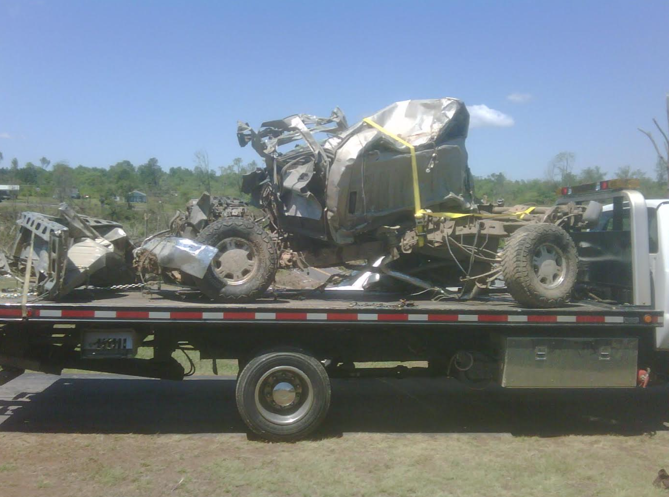
Three images of extreme damage in Hackleburg. At top left, a view of large trees that were completely debarked near the Wrangler Factory (Courtesy of Patrick Flanagan). At top right, a vehicle that was rendered unrecognizable in the vicinity of Clay Street (Courtesy of John Phillips). At bottom, the tornado was powerful enough to rip concrete from the ground (Courtesy of Niccolò Ubalducci)

The Wrangler denim factory, the largest employer in Hackleburg, was reduced to a pile of twisted metal. Fortunately, the factory was nearly empty when the tornado struck and only one employee was killed. (Bill Castle / ABC 40)

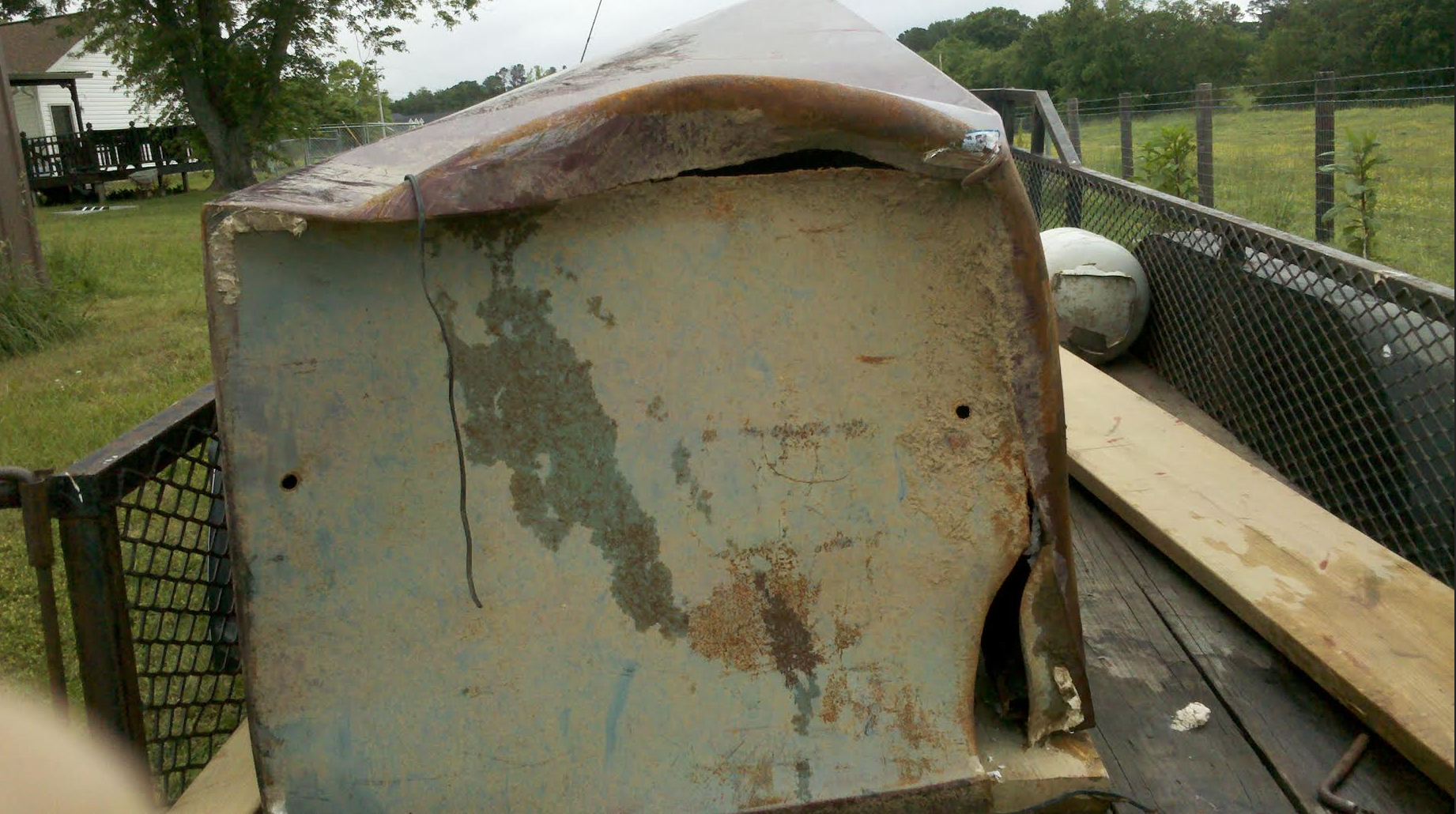
Views of extreme damage to the Wrangler factory. Tattered jeans were found more than 50 miles away. Additionally, vehicles in the area were carried long distances, and some were so thoroughly mangled that they were impossible to identify. (Imagery courtesy of Niccolò Ubalducci)

Aerial views of damage near the Wrangler factory with street views of the respective buildings before the tornado. Extensive wind rowing was visible after the tornado, a damage feature unique to the most violent tornadoes. (Damage shot by Bill Castle / ABC 40).

The tornado maintained EF5 intensity through eight miles of forest before sweeping away homes on Woodard Road, located one mile southwest of downtown Phil Campbell. The tornado was traveling at approximately 70mph at this time.

The tornado followed Highway 237 into the small town of Phil Campbell. There were multiple fatalities as homes on both sides of the road were obliterated in EF5 fashion. The unrecognizable appearance of the tornado coupled with its incredible forward speed led to 26 deaths in Phil Campbell despite extensive warning. There was an unconfirmed account from a local emergency worker of bodies that were carried over half a mile.

Online discussion of the Phil Campbell tornado brought forth images of an underground storm cellar on Highway 237 that lost its concrete roof in the storm. No official media sources covered this incredible feat of damage, but photographic evidence appears to confirm its occurrence. (Talkweather forum, 2012)

Second view of the tornado damage in southwestern Phil Campbell. The damaged storm cellar is visible at center left.

Before and after views of Pinion Drive from Highway 237. A large, likely well-constructed brick home was swept away on the east side of the road, leaving nothing but an exposed basement. (Image courtesy of John Phillips)

NWS image of a brick home that was swept from its foundation on Highway 237.

Homes on Stalcup Circle were reduced to a patchwork of EF1 to EF5 damage. The corridor of extreme winds passed near the eastern edge of the cul-de-sac. Businesses in downtown Phil Campbell (visible at top) were heavily damaged but spared the intense inner core of the fast moving tornado.

Extreme damage in Phil Campbell. At left, a large tree that was partially debarked and stripped of branches (Courtesy of John Phillips). At left, grass scoured from a hillside (Courtesy of Mary Karera).

There were fatalities in all four devastated homes visible on Brown Avenue (from top center to center). A large section of pavement was peeled away at the intersection of Wyatt Drive and Brown Avenue (grey patch at center).

NWS survey image of scoured pavement on Wyatt Drive.

The tornado crossed County Road 81 and entered an unincorporated area just east of Phil Campbell. A narrow streak of extreme damage was made visible by wind damaged grass and empty foundations.

One woman died as a large, well-built brick home was swept completely away on Cornelius Drive. Nearby, several small frame homes were obliterated, resulting in two more fatalities. Damaged grass marked the path of the highest winds.

The tornado crossed Smith Road (not to be confused with the ‘Smith Lane’ mentioned in the NWS report) and left several bare foundations as it entered an unpopulated area to the east. Cars from homes on Cornelius Drive were hurled and rolled more than 150 yards (most of the cars visible at lower left are related to the damage clean-up).

Closer view of the remains of several frame homes on Smith Road. A couple was killed in the home at far left, and a ten year old boy was killed in the adjacent home. The tornado’s forward speed slowed to 60mph in eastern Franklin County.

After spending several miles leveling forests, the tornado thundered over County Road 38 and entered an area referred to as “Oak Grove.” Giant trees at distance were stripped of bark and branches. The core of the tornado moved from top right to center left.

According to the NWS survey report, the tornado may have reached peak intensity eight miles northeast of Phil Campbell in the unincorporated community of Oak Grove. Overall damage was remarkably uniform from Hackleburg to Oak Grove, however, and more pronounced vegetation scouring was noted at earlier points in the tornado’s path. A visible trail of wind damaged grass was left parallel to County Road 38. The few remaining trees were blown over and left clinging to the ground by only a few roots. Extreme damage was confined to a narrow corridor, but the EF0 damage contour reached its peak width of over one mile.

At top, two images of the EF5 damage streak through Hackleburg. At bottom left, the tornado’s path through Cornelius Drive, less than a mile east of Phil Campbell. At bottom right, the path through Oak Grove. Vegetation scouring indicates the tornado may have been at maximum intensity outside of Oak Grove. (Video stills by paulleah)

Another view of damage near Oak Grove Cemetary. A very large, well-constructed two story brick home (far right) was swept completely away, and a red corvette that had been parked at the residence was found mangled more than 200 yards to the east.

Street view of the large, two-story brick home that was swept completely away in Oak Grove. Surveyors found that the home had extensive foundation anchoring and was exceptionally well-constructed. The property owner was away when the tornado struck, but his grandson and grandson’s wife abandoned their trailer and sought shelter in the home as the tornado approached. The bodies of the young couple were found several hundred feet to the east of the foundation. (Stephens, 2011)

The remains of a frame home on Miller Road in Oak Grove. Vehicles hurled long distances by the tornado are visible near the property line.

Bare foundations near Alexander Drive in Oak Grove. One car in the area was blown so far that it remained missing at the time of the damage survey (NWS Report). In the distance, the remains of six large chicken houses that completely vanished in the storm.

The tornado weakened after causing additional EF5 damage near the community of Mount Hope. After skirting past the city of Decatur and crossing Wheeler Lake, the tornado re-intensified and left a trail of high-end EF4 damage in the town of Tanner. Large two and three bedroom homes were obliterated in one neighborhood, some of which were swept completely away. Four deaths occurred in the area, including one in a vehicle on the US 31. The tornado continued causing EF4 damage in Madison County, where eight fatalities occurred, before crossing into Tennessee and dissipating.
* Most of the aerial images used in this article were taken from HBTV’s picture gallery here.